
There is a unique club in the world known as GNSS, short for Global Navigation Satellite System. This exclusive group has only four members: the U.S. GPS, Europe’s Galileo, Russia’s GLONASS, and China’s Beidou. Despite its small size, this club captures the attention of world leaders and the interest of top scientists globally. Each system offers navigation and positioning services, but they differ in technology, coverage, and development goals.
China’s Beidou is the youngest and fastest-growing member of the club. It has rapidly evolved into one of the most powerful systems in terms of development and global influence. But what exactly is Beidou, and how does it impact our daily lives? This is an intriguing topic that many people are curious about. While there are numerous academic papers discussing Beidou, they often use complex terminology that can be hard for the general public to understand. As a result, many people find these articles uninteresting or difficult to engage with.

**1. The Origins of GPS**
On October 4, 1957, the Soviet Union launched Sputnik, the first artificial satellite, marking the beginning of the space age. The United States closely monitored this event. Two scientists, Bill Guier and George Weiffenbach, working at the Johns Hopkins Applied Physics Laboratory, noticed something unusual: the frequency of the satellite signal changed over time. They identified this as the Doppler effect, caused by the relative motion between the satellite and the ground.
Their research led to a groundbreaking discovery: if multiple ground receivers were used, the position of the satellite could be determined based on the differences in signal frequencies. Excited by their findings, they shared their results with their lab director, Frank McClure, who realized the potential of using this method for tracking satellites.
At the time, McClure was conducting a study for the U.S. Navy on how to track ships at sea. After hearing the scientists’ report, he had a sudden insight: if the system could determine where the satellite was, why not reverse it and use it to find where the ship was? That idea became the foundation for the GPS system.
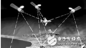
The next challenge was deciding which orbit the satellites should use. Low Earth Orbit (LEO) would offer high accuracy but required around 200 satellites to cover the globe—too costly. High Earth Orbit (HEO), while requiring only three satellites, had issues with accuracy and Doppler-based positioning. A medium orbit, however, offered a balance: 24–36 satellites could provide global coverage, and their movement allowed for more accurate Doppler measurements.
In 1978, the first GPS satellite was launched, and by 1995, the full system was operational. Today, there are 30 satellites in the constellation, with civilian access freely available worldwide.
**2. Is the U.S. Being a “Lei Feng�**
GPS has become an essential part of modern life, from car navigation to emergency response. People no longer rely on paper maps, and adventurers can now safely explore remote areas with confidence. But is the U.S. giving away such a valuable system for free, like a modern-day Lei Feng (a Chinese cultural symbol of selfless service)?
In reality, even if the U.S. wanted to charge for GPS, it would be nearly impossible. GPS is a one-way communication system, similar to a TV broadcast tower. It sends signals to users without knowing who is receiving them. This makes it impossible to track usage or collect fees.
Some might suggest selling expensive decoding chips, but the system is designed to be open and accessible. Encryption would be difficult and impractical given the low cost of consumer devices. Even if the military code were encrypted, it could be cracked quickly.
By offering free access, the U.S. has created a massive global market and strengthened its soft power. This approach aligns with national interests, making GPS a global public good.
However, GPS also poses a challenge for military applications. If an enemy country uses GPS, the U.S. cannot simply shut it off. But the civilian code is intentionally less accurate than the military version, and it is hidden. In a conflict, the U.S. could even send misleading signals, causing serious consequences.
Because of this, many countries have chosen to develop their own navigation systems. For smaller nations, building a global system is not feasible, but for major powers like China, it's a strategic necessity.
**3. The Birth of Beidou**
China has long recognized the importance of having an independent navigation system. Since the 1970s, the country has been working on its own satellite navigation program. During the Seventh Five-Year Plan, the “New Four Stars†initiative proposed different configurations, from single-star to multi-star global systems.
In the early 1980s, a team led by Yuan Xun Cheng proposed a two-satellite positioning system, which was seen as the best solution at the time. However, due to economic constraints, the project was delayed for a decade. The turning point came in 1991, during the Gulf War, when the U.S. GPS proved its military value. This realization pushed China to restart its plan.
Why didn’t China go for a 30-satellite system like the U.S.? At the time, the country lacked both the financial resources and technical experience. Instead, it started small, focusing on a two-satellite system. Some might question whether two satellites are enough for accurate positioning. The answer lies in the use of an altimeter, which allows users to calculate elevation manually, effectively acting as a third reference point.
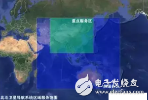
While this approach is cost-effective, it also comes with limitations. The two satellites operate in a high geostationary orbit, providing coverage mainly over China. This design, though technically sound, raised concerns about performance and reliability, leading to criticism of the early Beidou system.
Elevator Control Systems,Mr Elevator Controller Cabinet,Main Power Supply In Cabinet,Elevator Control Cabinet
ZHONG HAN INTERNATIONAL TRADE CO., LTD , https://www.cck-ht.com